Leg 6 - Calderdale Way Relay
Complete description of the Leg 6 route
Race Details
| Distance |
10.21 miles |
| Start |
Shelf (Bridle Stile Road), SE 122283 W3W ///dress.bake.ends |
| Finish |
Spring Hall Athletics Track, Halifax, HX3 0AQ, W3W ///rises.flip.hugs |
| Registration |
12:00 to 1:30 pm |
| First runners expected |
12.40 pm |
| Leg cut-off |
2.00 pm |
| Records |
|
| Link to map | |
| Read Instructions | Make sure to read these photographic instructions for route near start |
| Read Instructions | Make sure to read these photographic instructions of the middle section through the woods |
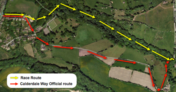
Race Map
Start of Leg 6 Route
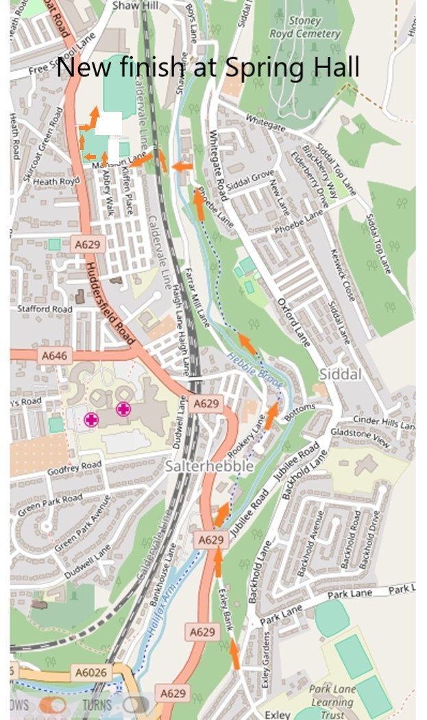
New finish at Spring Hall for 2019
Race Route
Make sure to read these photographic instructions on the middle section through the woods |
NEW ROUTE FROM 2025 ONWARDS: From the changeover, continue down the path for approximately 100m, then turn left where a path leads from the main trail. Continue down this path for approximately 200m until it meets the steps. Turn left down the steps and over the beck. |
Keep on the path, left of the fencing for 200m, then left at the stile and up through the trees and through the open fence. |
About 20m take the right path, down and over the wooden bridge follow the path bearing left, up to the top, metal gate on left. |
Go right, follow the way marker sign Berry Bottoms and keep on this path on the top side of the woods all the way until you meet the steps half way up. You are back on the Calderdale Way. |
Up the steps and continue on the CW. |
Keep to the right after the first stile, then stay on the upper path just inside the top of North Wood until a stream bed crosses where paths divide at an opening. |
Go diagonally up a field to a stile left of the nearest pylon; bear right along the wallside into a grassy lane past Middle Ox Heys which leads to the village street at Norwood Green. |
Turn left along the road for half a mile past the Old White Beare pub. |
Fork right at the war memorial, then left down a track past the swings, with Norwood Terrace on the left, and Upper Rookes Hall and a cricket field on the right. |
Cross a railway bridge, turn right to a field then left down a hedge-side and forwards over a slight ridge to the A58 Leeds-Halifax road near a lay-by. Note the fine view of Wyke Viaduct on the left. |
Cross the road to a stile beside a gate. |
Go through and follow the left hand hedge down this field to a wooden stile and round to the left until a stream is seen ahead and the path bears right to cross a footbridge, continuing forwards into a narrow ginnel between fences in a new housing estate. |
Emerge on Victoria Road and carry straight on down the road to the Punch Bowl Hotel in the centre of Bailiff Bridge. |
Turn left to the traffic lights and cross the road (A641) into Birkby Lane by the offices of Firths Carpets. Go up the hill and 50 yards before a rail bridge turn right into Birkhouse Road. |
Follow the road past the houses and bear left under an old railway bridge, continuing forwards along the lane. On the brow of the hill carry straight on as the road bends to the left. |
The unmade road leads up to Woolrow Farm on the skyline ahead. After the bungalow turn left over a stile; after a few yards turn right following wall and hedge down a series of fields to a stream at Hole Bottom. |
At the field corner is a footbridge leading up a short path to a metalled road (Thornhill Beck Lane). |
Turn right down the road for 200 yards then left up some steps and straight up the hill to a stile. |
Turn right onto Thornhills Lane following the road as it turns sharp right and left near a large house.After 200 yards turn right at a signpost onto a field path running downhill towards the old railway embankment. Note the fine view of Brighouse in front. At the bottom of the slope the path turns left alongside an old railway line. |
Cross the road (A643) and go down the short, steep street opposite (Alegar Street), then turn right onto Wakefield Road (A644), left into Grove Street and right along Mill Lane to The Barge pub. |
Turn left before Sainsbury's into Wharfe Street to the canal basin, now a centre for leisure cruising. |
Turn right along the canal towpath passing under several bridges as it goes through Brighouse. |
From Brighouse follow the canal towpath for half a mile to Ganney Lock (SE 140229), cross the bridge and continue on the left bank to a large factory overlooking Cromwell Lake. |
Turn right to cross the canal and Elland Road then left up Freeman's Wood, alongside a wall. Keep left when the track forks, staying next to the well, and climbing towards some power lines and a path junction. |
Turn left over a stile to descend 240 steps to a farm, Fort Montague, at Cromwell Bottom. At the bottom of the steps turn right along a grassy track climbing gently into Cromwell Wood. Continue uphill on a steady gradient for ¾ mile until you meet a cross path and signpost. |
Turn left for Southowram down a paved track, over a stream and left again to a farm lane. |
Turn sharp right and quickly left through a stile; keep the wall on the right through two fields and past some stables to School Lane and on to the Methodist Sunday School at the end. |
Turn right towards Southowram bus terminus at Milking Hill and left into West Lane towards Siddal. |
Go down West Lane and Change Lane as normal but DO NOT FOLLOW THE SIGNPOST CALDERDALE WAY halfway down Change Lane (which goes left through the fields at EXLEY) but keep on the road all the way down past the school on your left to the junction. Turn left then 1st right down Exley Bank (steep cobbled road) to the main road. Keep right and take care when crossing the side road at the traffic lights on your right (Jubilee Rd). Immediately after Jubilee Rd, go through a gap in the wall to your right onto Hebble Trail. |
Continue on the Hebble Trail (ignoring the turn to the left) and at Bottoms go straight forward along Hebble Trail until you reach Phoebe Lane, continue forward and round the left hand bend over a small bridge. On reaching the road go left for 20m and then make a sharp right turn up a steep cobbled path. After 50m the path goes over railway bridge and leads into Mansion Lane. 50m after the bridge turn right through gap in wall (do not go up first gap with steps) into Spring Hall, across the field to the finish. SEE ALSO MAP AT TOP OF INSTRUCTIONS. |